
Here’s the Top 10 Deadliest Earthquakes of all time. By “deadliest” we mean by death toll, fatalities or number of people who perished. In our list we will be ranking these disasters from lowest to highest by total deaths, including the epicenter geographic co-ordinates and estimated damage.
Deep breath 😞😞…let’s proceed.
FULL LIST
10th Deadliest Earthquake – Tokyo, Japan – 1923
9th Deadliest Earthquake – Dvin, Armenia – 893
8th Deadliest Earthquake – Iran (856) & China (1920)
7th Deadliest Earthquake – Sumatra, Indonesia – 2004
6th Deadliest Earthquake – Gyzndzha, Azerbaijan – 1139
5th Deadliest Earthquake – Tangshan, China – 1976
4th Deadliest Earthquake – Antakya, Turkey – 525
3rd Deadliest Earthquake – Antakya, Turkey – 115
2nd Deadliest Earthquake – Port-Au-Prince, Haiti – 2010
Deadliest Earthquake In Recorded History – Shaanxi, China – 1556
Below are the details of the Top 10 Deadliest Earthquakes in recorded history.
10th Deadliest Earthquake – Tokyo, Japan – 1923
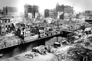
On Saturday, September 1, 1923, Japan experienced one of the most catastrophic events in its history – the Great Kantō Earthquake. Striking the Kantō Plain on the Japanese island of Honshū, the disaster began at 11:58:44 JST (02:58:49 UTC) on a day that would forever be etched in the memory of the Japanese people.
In the area closest to the earthquake’s epicenter, a rumbling sound emerged from deep underground, similar to the echoes of far-off thunder. This was followed by sudden, sharp upward jolts that quickly transformed into side-to-side movements, persisting for six minutes. The intensity was so severe that it was impossible to stand upright. Trees either snapped or were torn from their roots. Concurrently, a plume of smoke burst forth from Mihara volcano on Oshima Island, indicating its reaction to the seismic disturbance.
The immediate impact was catastrophic, with buildings collapsing, roads crumbling, and infrastructure being decimated. But the aftermath was even more harrowing. The quake sparked massive firestorms that engulfed Tokyo, creating fire tornadoes that added to the apocalyptic scene. These fires raged for days, leaving little but ashes in their wake.
In the quake’s aftermath, Japan faced a crisis of governance and societal strain, including tragic acts of violence against ethnic minorities, fueled by rumors and misunderstandings. This period was a test of the nation’s resilience and capacity for recovery.
Numerous aftershocks followed the main earthquake. In the initial 12 hours, 44 noticeable tremors were recorded, followed by 88 in the subsequent 12 hours. The next two 12-hour periods saw 60 and 47 tremors respectively. Tokyo’s less sensitive seismographs registered a total of 1700 shocks in the first three days alone.
MAGNITUDE: 7.9
EST. DEATHS/MISSING/INJURIES: 142,807 / 43,476 / 47,000
HOUSES DESTROYED: 695,000
EST. TOTAL DAMAGE COST (USD, BEF. INF.): 600 MILLION
EPICENTER LOCATION: 35.25 N, 139.5 E
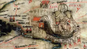
9th Deadliest Earthquake – Dvin, Armenia – 893
Number 9 in our Top 10 Deadliest Earthquakes, struck on December 24 in 893 AD in the region around Dvin, Ararat Province, Armenia (also affecting parts of neighboring Iran). The quake demolished residences, palaces, and churches, resulting in numerous fatalities among the residents buried under the debris.
The city was still reeling from the effects of another earthquake three decades prior. The devastation was almost total – all but approximately 100 buildings were reduced to rubble. This included the grand church and the palace of the Catholicos. The destruction spread across the Artashat plateau, where landslides compounded the devastation.
The politics of Armenia is the Middle Ages, was characterized by a complex interplay of internal fragmentation and external influences involving the Abbasid Caliphate and the Byzantine Empire. The political tug-of-war between the same, coupled with internal divisions, defined the intricate and unstable political landscape of Armenia during this period.
The city’s fortifications were severely compromised by the earthquake, leaving Dvin vulnerable. This vulnerability was exploited by Muhammad ibn Abi’l-Saj of the Abbasid Caliphate who captured the city and transformed it into a military stronghold. Despite the shift of Armenia’s capital to Ani in 961, Dvin experienced a resurgence in prosperity in the 10th century, flourishing again after it was rebuilt.
This disaster happened the Middle Ages, long before modern seismography so a lot of what is known about the earthquake and its devastation was pulled from historical sources, many of which differ. Several accounts state that the event was preceded by a Lunar or Solar Eclipse along with other weather and environmental anomalies.
MAGNITUDE: 6.0
EST. DEATHS/MISSING/INJURIES: 150,000 / UNKNOWN / UNKNOWN
HOUSES DESTROYED: UNKNOWN
EST. TOTAL DAMAGE COST (USD, BEF. INF.): UNKNOWN
EPICENTER LOCATION: 40 N, 44.6 E
8th Deadliest Earthquake – Iran (856) & China (1920)
Tying for 8th place in out Top 10 Deadliest Earthquakes, are two equally horrific earthquakes.
Damghan, Iran
Striking on December 22, 856 AD, the Iran earthquake devastated the area around the Parthian city of Damghan in the district of Qumis, which was hardest hit. It was then part of the Abbasid Caliphate.
In the mountainous areas, the earthquake caused significant ground changes, likely including surface faulting. Shahr-i Qumis, the old capital of the province, suffered extensive damage and was likely deserted permanently following the earthquake. In Bustam, a third of the structures were destroyed. Even two generations later, the area stretching from Bustam to Damghan still bore scars from this seismic event. The tremor also impacted regions like Tabaristan and Gurgan. One of the most severe consequences was on the water systems in the Qumis district. The earthquake either led to the drying up of springs and qanats or caused landslides that blocked the streams, severely disrupting the water supply to the plains. Aftershocks continued for a few years afterward.
MAGNITUDE: 7.9
EST. DEATHS/MISSING/INJURIES: 200,000 / UNKNOWN / UNKNOWN
HOUSES DESTROYED: UNKNOWN
EST. TOTAL DAMAGE COST (USD, BEF. INF.): UNKNOWN
EPICENTER LOCATION: 36.2 N, 54.3 E
Gansu, China
The China Earthquake of 1920 is called the Gansu Earthquake or otherwise the Haiyuan Earthquake. It struck in the year 1920 on Dec 16, at 20:05:53 Beijing time in Haiyuan, Ningxia Autonomous Region at a depth of 17KM. In certain locations, the terrain was dramatically altered, forming towering mounds and deep valleys. Mountains experienced avalanches, the earth split open, and dark waters surged forth. This catastrophic event led to the complete devastation of four cities.
A significant number of survivors succumbed to the cold. Continuous aftershocks instilled a fear of constructing anything beyond makeshift shelters, and as a result, many who had endured the initial earthquake did not survive the harsh winter that followed.
MAGNITUDE: 8.3
EST. DEATHS/MISSING/INJURIES: 200,000 / UNKNOWN / UNKNOWN
HOUSES DESTROYED: UNKNOWN
EST. TOTAL DAMAGE COST (USD, BEF. INF.): 25 MILLION
EPICENTER LOCATION: 36.7 N, 104.9 E
7th Deadliest Earthquake – Sumatra, Indonesia – 2004
Also known as the Indian Ocean and the Sumatra-Andaman Earthquake, this catastrophic earthquake struck off the coast of Sumatra, Indonesia on December 26 2004 but was recorded worldwide, affecting several other countries.
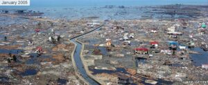
Considered one of the deadliest natural disasters in recorded history, the quake was caused by the subduction of the Indian Plate beneath the Burma Plate and lasted an exceptionally long duration of between 8.3 and 10 minutes. Its epicenter was located in the Indian Ocean, near the west coast of northern Sumatra.
Subsequent to the initial quake, the region experienced daily aftershocks, some reaching up to magnitude 7.2, for approximately three to four months. These ongoing tremors, along with the aftershocks, maintained the seismic activity in the area well beyond the primary event. According to the U.S. Geological Survey (USGS) the earthquake had energy equivalent to 23,000 Hiroshima-type atomic bombs.
The most devastating aftermath of the Sumatra earthquake was the massive tsunami it triggered, which affected 14 countries around the Indian Ocean. With waves reaching heights of up to 30 meters, the tsunami caused unimaginable destruction along the coasts of Indonesia, Sri Lanka, India, and Thailand. In Indonesia, particularly in Aceh province, entire towns and villages were wiped out, leaving a trail of destruction and loss. There was also severe damage to local ecosystems and wildlife.
The disaster also displaced millions and caused extensive damage to infrastructure, homes, and livelihoods, leading to a humanitarian crisis of immense proportions. The 2004 Sumatra earthquake and tsunami underscored the need for improved early warning systems and international cooperation in disaster response and preparedness, leading to significant changes in these areas in the years that followed.
Several works in popular culture were made surrounding the events of this disaster most notably the feature film The Impossible in 2012 starring Naomi Watts and Ewan McGregor.
MAGNITUDE: 9.1
EST. DEATHS/MISSING/INJURIES: 227,899 / 43,789 / 125,000
HOUSES DESTROYED: 1.7 MILLION DISPLACED
EST. TOTAL DAMAGE COST (USD, BEF. INF.): 10 BILLION
EPICENTER LOCATION: 3.316°N, 95.854°E
6th Deadliest Earthquake – Gyzndzha, Azerbaijan – 1139
Striking the prosperous city of Gyandzha in 1139 AD – known today as Ganja in modern-day Azerbaijan – the earthquake left an indelible mark on the region’s history. Reports from that era indicate a calamity of staggering proportions, with the earthquake completely leveling the densely populated city. Estimates aside it is said that the lost of life in the area is incalcuable
The aftermath of the earthquake had significant socio-economic and cultural implications. Gyandzha, before the earthquake, was a thriving city, known for its architectural marvels, intellectual contributions, and economic vitality within the Seljuk Empire. The disaster not only took a massive human toll but also brought about the destruction of numerous architectural and cultural landmarks. This event led to a profound and lasting change in urban planning and building strategies in the region. Furthermore, the Gyandzha earthquake of 1139 serves as a stark historical example of the potential impacts of natural disasters on human societies, highlighting the importance of resilience and preparedness in the face of such calamities.
MAGNITUDE: 7.0
EST. DEATHS/MISSING/INJURIES: 230,000 / UNKNOWN / UNKNOWN
HOUSES DESTROYED: UNKNOWN
EST. TOTAL DAMAGE COST (USD, BEF. INF.): UNKNOWN
EPICENTER LOCATION: 40.3 N, 46.3 E
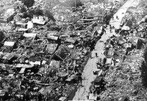
5th Deadliest Earthquake – Tangshan, China – 1976
It struck the industrial city of Tangshan in Hebei Province, China, on July 28, 1976. With its epicenter near Tangshan, the earthquake, the quake hit in the early hours of the morning, catching many residents asleep and unprepared, which contributed to the high death toll. The earthquake itself comprised of two main shocks (7.5 and 7.0 respectively) followed by a long sequence of aftershocks.
The aftermath of the Tangshan earthquake brought significant changes in both China’s approach to disaster management and its scientific community’s understanding of seismology. Prior to the earthquake, Chinese seismologists had expected a significant earthquake to occur in another region and were caught off guard by the Tangshan quake.
In response, China invested heavily in earthquake research and monitoring, improving its ability to predict and respond to future seismic events. The disaster also prompted international aid and sympathy, marking one of the first times since the beginning of the Cultural Revolution that China accepted foreign assistance. This event, thus, not only shaped the field of seismology in China but also had lasting effects on the country’s policies towards international cooperation and disaster preparedness.
MAGNITUDE: 7.5
EST. DEATHS/MISSING/INJURIES: 242,769 / UNKNOWN / 799,000
HOUSES DESTROYED: 85% OF CITY’S BUILDINGS
EST. TOTAL DAMAGE COST (USD, BEF. INF.): 5.6 BILLION
EPICENTER LOCATION: 39.57 N, 117.98 E
4th Deadliest Earthquake – Antakya, Turkey – 525
The Antakya earthquake of 525 was a significant seismic event that struck the city of Antakya, historically known as Antioch, in what is now modern-day Turkey. This earthquake is remembered as one of the most destructive in the region’s history, occurring in an era when Antioch was a major city of the Byzantine Empire, renowned for its architectural splendor and cultural importance. Striking at mid-morning, the quake caused extensive damage to the city, leveling many of its buildings and causing a substantial loss of life. Historical records suggest that the earthquake was accompanied by other natural disasters, such as fires, which compounded the devastation and hampered rescue and recovery efforts.
In the aftermath of the earthquake, Antioch faced a challenging period of rebuilding and recovery. The city, which had been a significant center of early Christianity and a hub of commerce and culture, was profoundly affected both physically and socio-economically. The Byzantine Empire, under the reign of Emperor Justin I, undertook efforts to rebuild the city, reflecting the importance of Antioch as a key urban center in the empire. The earthquake in Antakya in 525 is not only remembered for its immediate impact but also for its historical significance, as it marked a turning point in the city’s history, influencing its architectural and urban development in the centuries that followed.
MAGNITUDE: 7.0
EST. DEATHS/MISSING/INJURIES: 250,000 / UNKNOWN / UNKNOWN
HOUSES DESTROYED: UNKNOWN
EST. TOTAL DAMAGE COST (USD, BEF. INF.): UNKNOWN
EPICENTER LOCATION: 36.23°N, 36.12°E
3rd Deadliest Earthquake – Antakya, Turkey – 115
About 400 years before the 525 AD disaster was another, the 115 AD earthquake, also in the city of Antioch (Antakya). During this period, Antioch was one of the Roman Empire’s largest cities, famed for its grandeur and cultural significance. The earthquake delivered a massive blow to the city by night, causing widespread destruction to its infrastructure and buildings, including many landmarks of the Roman period. The exact magnitude of the quake is unknown, but historical accounts describe considerable damage and a high number of casualties, indicative of a major seismic event. The catastrophe was further exacerbated by the onset of fires, which were common following earthquakes in ancient cities due to the prevalent use of oil lamps.
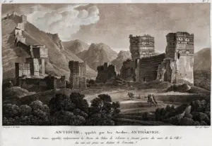
In response to the disaster, the Roman Empire undertook significant efforts to rebuild Antioch, reflecting the city’s importance as a key political and economic center. Emperor Trajan, who was in the region at the time of the earthquake, initiated the reconstruction efforts. These rebuilding projects were continued by his successor, Hadrian, and focused on restoring the city’s former glory while also implementing improvements in urban design and construction to mitigate the impact of future earthquakes.
MAGNITUDE: 7.0
EST. DEATHS/MISSING/INJURIES: 260,000 / UNKNOWN / UNKNOWN
HOUSES DESTROYED: UNKNOWN
EST. TOTAL DAMAGE COST (USD, BEF. INF.): UNKNOWN
EPICENTER LOCATION: 36.23°N, 36.12°E
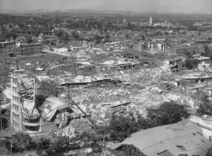
2nd Deadliest Earthquake – Port-Au-Prince, Haiti – 2010
The 2010 earthquake in Port-au-Prince, Haiti, was a catastrophic disaster that struck on January 12, 2010. The epicenter was at a depth of 13 kilometers located just 25 kilometers (16 miles) west of Haiti’s capital, Port-au-Prince, making it devastatingly close to the densely populated urban area. The quake, along with its numerous aftershocks, inflicted unprecedented damage on the city and its surrounding regions. The infrastructure of Port-au-Prince, already vulnerable due to economic challenges and poor construction standards, was severely impacted. Buildings, homes, and historical landmarks crumbled, leaving behind a landscape of destruction and debris.
In the days following the earthquake the U.S. Geological Survey said it recorded 52 aftershocks of magnitude 4.5 or greater. The earthquake occurred in the boundary region separating the Caribbean plate and the North America plate.
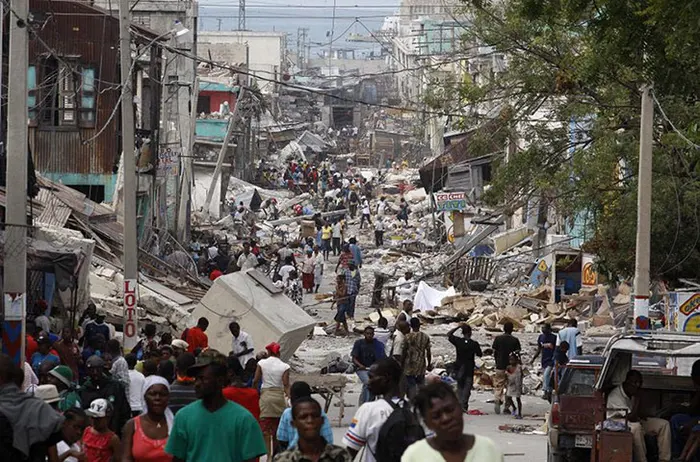
The humanitarian aftermath of the earthquake was overwhelming. The international community responded swiftly with an outpouring of aid, but the scale of the disaster posed significant challenges for relief efforts. Basic necessities like food, water, and medical supplies were in critically short supply. The destruction of government buildings, including the Presidential Palace, and the loss of many government officials further complicated the coordination of these efforts. In addition to the immediate needs, there was a rapid spread of diseases, most notably a cholera outbreak, which further strained the already limited healthcare resources. The disaster highlighted the dire need for improved infrastructure and emergency preparedness in disaster-prone regions like Haiti.
Long-term recovery and rebuilding efforts in Haiti following the 2010 earthquake have been a complex and ongoing process. The international community pledged billions of dollars in aid for reconstruction, but the actual implementation of these funds and projects faced numerous obstacles, including political instability, logistical challenges, and concerns over the effective management of resources. Despite these challenges, the earthquake brought global attention to Haiti’s vulnerability to natural disasters and the critical need for sustainable development. Efforts to rebuild have included a focus on stronger building codes, community-based approaches to redevelopment, and initiatives aimed at improving the overall resilience of the nation to future earthquakes and other disasters. The 2010 Haiti earthquake remains a poignant reminder of the devastating impact natural disasters can have, particularly in regions struggling with poverty and political instability.
MAGNITUDE: 7.0
EST. DEATHS/MISSING/INJURIES: 316,000 / UNKNOWN / 300,000
HOUSES DESTROYED: 188,383
EST. TOTAL DAMAGE COST (USD, BEF. INF.): 8 BILLION
EPICENTER LOCATION: 18°28′N, 72°32′W
Deadliest Earthquake In Recorded History – Shaanxi, China – 1556
The 1556 Shaanxi earthquake, occurring on January 23, 1556, in the Ming Dynasty, is considered the deadliest earthquake on record. Also called the Jiajing Great Earthquake its impact was extensive, affecting areas as far as 500 kilometers away from the epicenter with aftershocks felt up to 6 months after the fact.

One of the most devastating aspects of the Shaanxi earthquake was the massive loss of life and destruction of property in the densely populated Wei River Valley. The region was heavily populated with a large number of people living in artificial caves called Yaodongs, carved into the soft loess hillsides. These structures, while efficient for the climate and lifestyle of the region, proved to be deadly during the earthquake. The quake triggered landslides and collapses of these cave homes, burying residents alive. In addition to human casualties, numerous historical records, cultural artifacts, and architectural marvels were lost, severely impacting the cultural heritage of the region.
The impact of the earthquake was vividly captured in the accounts of those who witnessed it firsthand. The Ming Veritable Records, an authoritative historical source, details how “great fissures burst open in the earth” throughout the cities in Shaanxi province. Qin Keda, whose experiences were later translated into French by the scholar Jean-Paul Poirier, provides a harrowing personal account. He recounts being abruptly awakened by the quake’s tremors, saying, “In a rush, I reached for my clothes… struggling to stand, as if overcome by dizziness.” He managed to flee his home through a crack that had formed in the wall, only to discover his family already outside. Qin Keda’s narrative emphasizes the extent of the catastrophe, noting, “An uncountable number of homes lay in ruins,” and all he could discern amidst the chaos were the cries of people.
The aftermath of the earthquake saw a monumental effort in recovery and rebuilding. The Ming government of the time was involved in the relief efforts, although the extent and effectiveness of these efforts are subject to historical debate. The disaster had far-reaching effects on the social and economic fabric of Shaanxi and surrounding provinces, exacerbating the suffering caused by an already challenging period marked by political and social strife. The 1556 Shaanxi earthquake is not only a historical record of one of the most tragic natural disasters but also serves as an important case study for understanding the impacts of earthquakes on human societies, particularly in regions with vulnerable infrastructure and high population densities.
MAGNITUDE: 8.0
EST. DEATHS/MISSING/INJURIES: 830,000 / UNKNOWN / UNKNOWN
HOUSES DESTROYED: 50% of city walls, temples, governmental offices and civilian houses
EST. TOTAL DAMAGE COST (USD, BEF. INF.): UNKNOWN
EPICENTER LOCATION: 34°30′01″N, 109°18′00″E
Earthquakes are terrible, but fortunately not all of them are deadly. With preparation and forewarning, many lives can be saved. If you want to know more, check out the US Geological Survey for the latest alerts and to know more about earthquake science. Also be sure to bookmark the Red Cross Earthquake Safety Tips. Also bookmark the Tsunami Warning Centre for real time alerts.
The National Centers for Environmental Information is a great resource to search historical earthquake data.
Thanks for reading and be safe, always.